SafirMap
Link to the map of all the Safir boats we know
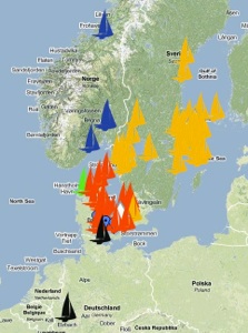
How to use
The map can be used for linking up all the Safir boats that has been built. The good thing about it is that you see the boats exactly where they are in their daily environment.
Other spots you can mark:
Nice places fore anchoring
Good places to eat
Nice trips
Where to buy stuff
Where to repair
Send the coordinates together with the story or the link to your homepage.
Se the instruction on how to use the map.

Mobile on the sea
The map can be seen on mobile devices as iPhone and iPad and devices like them. The map is at hand when you sail.
It is best to use it on wifi. Outside the wifi you will pay rooaming.
If you have a subscription to datadownload of 1-10GB with your netprovider you may be free to roam within your country limits.
Updating information
If you want to move your boat to the right habour. Please send me the coordinates of the boat lying on a mooring or at the boat bridge.
How to get coordinates from the GoogleMap
1 Right / ctrl click on the spot and chose from the popup menu “Directions from here” and copy the coordinates from the emerging left popup menu.
2 Right / ctrl click on the spot and chose from the popup menu “Drop LatLng marker” and copy the coordinates from the marker.
Is your contact information not right. Please correct them.
Send me a mail